Written by Julius Jürgens
Biography
The Greek author Strabo was born in the first third of the first century BCE in the northern Anatolian town of Amaseia in the ancient province of Pontos. Due to the subjects of his literary work, he occasionally is referred to as a geographer and historian.1 His best-known work, the seventeen-volume “Geographiká”, has almost completely been preserved except for a short section.2 It contains geographical and partly historical descriptions, which he had written on the basis of reports from his own trips as well as secondary sources.3 Another significant work by Strabo, the historical encyclopedia “Historiká Hypomnémata”, is considered to be lost.4
With his friend and then praefectus Aegypti Aelius Gallus (27/26–25/24 BCE)5, Strabo travelled through Egypt and subsequently lived in Alexandria probably until 20 BCE.6 The journey with the prefect along the River Nile, described for the most part in the seventeenth book of his “Geographiká”, took him to Syene and the borders of Ethiopia.7
Syene
Strabo reports that the city of Syene is situated at the border between Egypt and Ethiopia8 and in close proximity (“[…] at the distance of half a stadium […]”)9 to the Island of Elephantine, which is located in between the banks of the Nile.10 Three of the nine Roman cohorts of the province of Aegyptus were stationed in Syene.11
Strabo describes a historical event, in which the Ethiopians took advantage of the absence of large parts of the Roman army during Aelius Gallus’ expedition to Arabia and invaded Syene, Elephantine and Philae with about 30,000 men.12 Strabo delivers more details: “[they] enslaved the inhabitants, and threw down the statues of Caesar.“13 Petronius, who was appointed prefect (24-22 BC)14 at the time of Aelius Gallus’ absence, was able to liberate the cities and push the occupiers back to the city of Pselchis (Dakka) with the help of 10,000 soldiers and 800 cavalrymen.15 Roman ambassadors had been sent there by Petronius to reclaim the loot and ask the attackers about the motives for their invasion.16 They reported that they had been wronged by the “nomarchs” – the Romans replied that not these were the rulers of the country, but Caesar.17 As the Ethiopians did not meet any of the demands, Petronius’ troops attacked and pushed them so far back that they no longer posed a threat.18 A peace treaty between Emperor Augustus and Ethiopian ambassadors later was signed on Samos.19
Because of Syene’s geographical location at the Northern Tropic, the gnomons and sundials did not cast any shadows20 at the time of the summer solstice and the direction of the shadow changed depending on whether the observation site was north or south of Syene. Furthermore, Strabo writes about a well21 (φρέαρ) which was supposed to indicate this very day, by being illuminated to the ground by the sun standing in the zenith.22
Elephantine
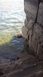
Fig. 1: Scales of the Nilometer at Elephantine, Photo by Stefanie Schmidt.
According to Strabo, the Island of Elephantine was home to a town with a temple of Chnum and the Nilometer, which he compares to that in Memphis.23 The Nilometer in Elephantine was a well (φρέαρ) on the river bank, which indicated the rise and fall of the River Nile’s water level (See Fig. 1 and 2). Strabo does not give any specific numeric values regarding these measurements, but rather uses the terms “low”, “medium” and “high” to describe the water depth.24 The inscribed entries have been preserved and published in modern times.25 Apparently, they are from the time period between Augustus and Septimius Severus (until 193 CE). They were written in Demotic and Greek and included not only the emperor’s names but also those of the prefects. Strabo also reports that the measurement results and forecasts were brought to the public, as the water levels had a significant impact on agriculture and thus on the economy of the surrounding area.26
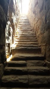
Fig. 2: Staircase of the Nilometer at Elephantine, Photo by Stefanie Schmidt.
Moving slightly upstream from Elephantine, Strabo visited the first Nile cataract.27 This geological formation consisted of flat rocks in the middle of the river and impassable rapids. Supposedly, there were navigable sections near the shore that could be passed against the flow.28 In a short anecdote, Strabo reports how during their stay local boatmen performed daring stunts by first sailing upstream and then using the cataract rocks as a ramp for risky jumps for the amusement of the prefect and his illustrious travel company.29
Philae
After crossing a road framed with hermae-like stone markers of black rock in a flat area outside Syene by wagon (ἀπήνη), Strabo took a light boat (πάκτων) made from wooden sticks to transfer to the island of Philae. There were Egyptian temples in which a falcon (ἱέραξ) was worshipped, but its size and plumage differed from the usual falcons known to him.30 According to people of the local population, these birds came from Ethiopian territory and were replaced by another one after the death of each specimen – the one shown to them seemed to have been on the verge of exchange, as it looked sick and almost dead, so Strabo.31 As he mentions twice, Philae’s population consisted of both Egyptians and Ethiopians.32
- DNP XI (2001) 1021 s. v. Strabon (S. Radt). ↩
- DNP XI (2001) 1022 s. v. Strabon (S. Radt). ↩
- DNP XI (2001) 1022–1024 s. v. Strabon (S. Radt). ↩
- DNP XI (2001) 1022 s. v. Strabon (S. Radt). ↩
- For the term of office of this prefect, see Jördens 2009, 403, note 18. ↩
- DNP XI (2001) 1022 s. v. Strabon (S. Radt). ↩
- Str. II 5.12. The Nile cruise is also mentioned in Str. XI 11.5; Str. XVII 1.24; Str. XVII 1.29; Str. XVII 1.46. See also DNP XI (2001) 1022 s. v. Strabon (S. Radt). ↩
- The term “Ethiopia” in Strabo’s work does not describe the territory of today’s Republic of Ethiopia, but rather serves as a collective name for the people beyond the borders of Upper Egypt at that time. See DNP VIII (2000) 1039 f. s. v. Nubien (S. Seidlmayer). ↩
- Str. XVII 1.48. Corresponds to ca. 100 m, see DNP XI (2001) s. v. Stadion (H. Schulzki; W. Decker; C. Höcker). ↩
- Str. XVII 1.48. ↩
- Str. XVII 1.48. From Str. XVII 1.12, it is known that a legion and three other cohorts were stationed in Alexandria. Two other legions, three cohorts and three cavalry units were scattered across the rest of the province. ↩
- Str. XVII 1.54. ↩
- Str. XVII 1.54. ↩
- For more information about Petronius, see Jördens 2009, passim; Bagnall 1985. ↩
- Str. XVII 1.54. ↩
- Str. XVII 1.54. ↩
- Str. XVII 1.54. ↩
- Str. XVII 1.54. ↩
- Str. XVII 1.54. ↩
- Str. XVII 1.48. The authenticity of the statement that the gnomons did not cast shadows is controversial among some translators, see Hamilton – Falconer 1856, 264; Radt 2009, 492. Modern editions citing this passage with reservation: Kramer 1852, 394; Meineke 1898, 1140. Further statements on the shadows of the gnomons: Str. II 5.7. ↩
- Str. II 5.37. ↩
- Str. XVII 1.48. It should be noted, however, that the turning circles do not have a constant geographical location and are constantly shifting. W. Falconer notes that in Strabo’s lifetime, the Tropic circle has already been so far from Syene that the phenomena described here could no longer have occurred. Hence, the bottom of the well would not have been fully illuminated. See Hamilton; Falconer 1856, 264. For another comment on the well, see Radt 2009, 492. ↩
- Str. XVII 1.48. ↩
- Str. XVII 1.48. See also Radt 2009 491. ↩
- Bernand 1989, No. 251. ↩
- Str. XVII 1.48. ↩
- Str. XVII 1.49. ↩
- Str. XVII 1.49. ↩
- Str. XVII 1.49. ↩
- Str. XVII 1.49-50. ↩
- Str. XVII 1.49. ↩
- Str. I 2.32; Str. XVII 1.49. ↩